
Watersheds are made up of several rivers, streams, bays, bayous, creeks, forests, and wetlands and are great sources of productivity that support a rich and diverse community of fish and wildlife. Ecologically diverse (variety of features and species), our watersheds include blackwater rivers, floodplain swamps, tidal marshes, seagrasses, and oyster beds. Unfortunately, these habitats have suffered declines in recent decades and need our help to bounce back and restore resilience. The water resources that comprise the Pensacola and Perdido Bay systems provide numerous functions that are critical to our quality of life. The watersheds' wetlands and floodplains store and regulate stormwater runoff, protecting water quality, protecting against floodwaters, and recharge aquifers and potable water supplies. The rivers, streams, and coastal waters sustain numerous species of fish, shellfish, and wildlife, and their wetlands and coastal barriers provide protection against storms and coastal change. Our community relies on these natural resources to sustain our economies and our quality of life.
Watershed - refers to the area of land that drains all streams and rainfall into a common outlet, such as a bay, bayou, or a larger body of water.
Estuary – Simply defined as “where the river meets the sea”. In other words, an estuary is where freshwater meets saltwater.
Resilience – The capacity of an ecosystem to recover after a disturbance (e.g. hurricane, habitat loss/destruction, oil spill). Therefore, the quicker the recovery, the more resilient.
Diversity - the variety of life in a particular habitat or ecosystem (plants and animals).
Floodplain – an area of low-lying ground adjacent to a stream or river that is subject to flooding, which acts as a buffer between a river and an inhabited area.
Water table - The level below which the ground is saturated with water.
Aquifer - An underground layer of permeable (allowing liquids/gases to pass through) rock, sediment, or soil that yields water to wells or springs.

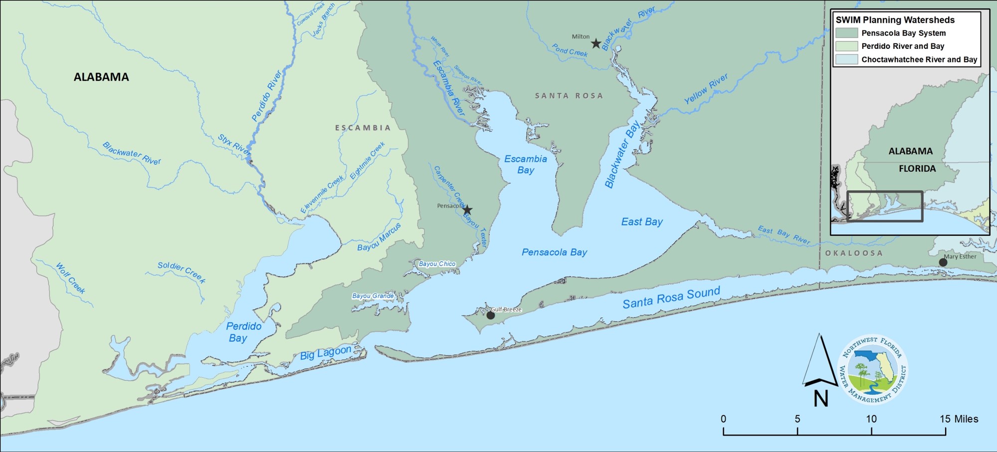
Perdido Bay alone covers approximately 50 mi², but its entire watershed covers over 1,250 square miles of northwest Florida and southern Alabama. Perdido Bay is connected to the Gulf of Mexico through Perdido Pass and the Gulf Intracoastal Waterway. Within Florida, the watershed covers approximately 350 square miles and extends into the Pensacola metropolitan area. Features include the Perdido River and tributaries such as Brushy Creek, Boggy Creek, McDavid Creek, and Jacks Branch. Estuarine waters include the main body of Perdido Bay, as well as Tarkiln Bayou, Weekly Bayou, Bayou Garcon, and Bayou Marcus. Public and private conservation lands that help protect water and related resources include state parks, water management lands, and portions of the Gulf Islands National Seashore. The Perdido River, Perdido Bay, their contributing tributaries and component wetlands, floodplains, bayous, bays, and other water and related resources provide numerous functions critical to our quality of life. The population in the Florida portion of the watershed has increased over the last several decades.

The Pensacola Bay Watershed consists of approximately 126,000 acres, including 550 miles of coastline and 144 mi² of open surface waters encompassing multiple cities and counties. The watershed in its entirety covers about 6,800 square miles of northwest Florida and southern Alabama, which includes many different counties, cities, and municipalities. Approximately 60% of the watershed is located outside of the state lines of Florida into the upper reaches of Alabama. The bay system encompasses the combined drainage area of Escambia, Blackwater, and Yellow River watersheds in addition to Escambia, Pensacola, East, and Blackwater Bays. Santa Rosa Sound, and Big Lagoon. The western portion of the basin is predominately urban, whereas the eastern and southern portions are primarily rural and undeveloped due to Eglin Air Force Base, the Yellow River Marsh Aquatic Preserve State Park, the Gulf Islands National Seashore, and Fort Pickens State Park Aquatic Preserve. The bay system is connected to the Gulf of Mexico through the Pensacola Pass, which is bordered by Fort Pickens to the East and Fort McRee to the West.